
Vietnam transport infrastructure 2026: Which Logistics Corridor Fits Your Factory
Vietnam transport infrastructure 2026 developments dictate that where you put your factory determines what you pay for logistics for the next ten years. That sentence sounds obvious. But I have watched investment committees approve site selections worth tens of millions of dollars based on industrial zone lease rates and labor availability — without ever modeling the connectivity of vietnam transport infrastructure 2026 grids that determines whether a container reaches the port in ninety minutes or four hours. In a sector where COGS consumes approximately 88% of revenue, that difference is not a minor variable. It is the variable that makes or breaks your operating margin.
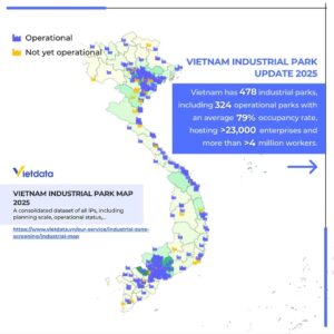
Strategic map of Vietnam transport infrastructure 2026, analyzing logistics corridors and the distribution of key industrial zones.
The network of vietnam transport infrastructure 2026 is in the middle of its most significant transformation in a generation. Deep-sea port expansion at Cai Mep and Lach Huyen, the construction of Long Thanh International Airport, and the completion of critical expressway segments are all converging in the 2026–2030 window. For manufacturers in the Vietnam Transportation Equipment Manufacturing sector (VSIC 30) — shipbuilders, rail equipment makers, aerospace component assemblers — this modern vietnam transport infrastructure 2026 buildout is reshaping which locations offer sustainable cost advantage and which ones are about to become expensive.
1. Two Corridors, Two Operating Realities of Vietnam Transport Infrastructure 2026
Vietnam’s manufacturing geography divides into two distinct clusters, and understanding the infrastructure difference between them within the vietnam transport infrastructure 2026 framework is the foundation of every other logistics decision — which port to use, which carrier to contract, how much your port-to-warehouse costs will actually run, and which compliance pathways apply.
1.1. The Northern Corridor and Northern Vietnam Transport Infrastructure 2026 (Hanoi – Hai Phong – Quang Ninh)
The northern cluster is increasingly the destination for heavy industrial operations diversifying from China. Three infrastructure advantages define this northern sector of vietnam transport infrastructure 2026:
Lach Huyen deep-sea port handles vessels up to approximately 145,000 DWT and provides direct access to trans-Pacific and Asia-Europe shipping routes. While it cannot match Cai Mep’s ultra-large vessel capacity, its direct expressway connection to Hanoi’s industrial hinterland — the Hanoi–Hai Phong Expressway — provides something the south cannot: uninterrupted, high-speed linkage from deep-sea berth to factory gate with no urban congestion chokepoints.
This connectivity advantage is the primary reason why northern corridor port logistics costs run 17–21% lower than southern equivalents. It is structural, not cyclical — it is built directly into the road network of the vietnam transport infrastructure 2026 plan, and it will persist for as long as the south lacks an equivalent dedicated industrial corridor.
VSIC 30 concentration: Shipbuilding (Hai Phong, Quang Ninh) and rail equipment manufacturing. The northern cluster’s proximity to Chinese supply chains supports the China+1 sourcing model that is reshaping regional industrial investment through the vietnam transport infrastructure 2026 system. Gemadept’s Nam Dinh Vu expansion (Phase 3, ~800,000 TEU) signals that major logistics operators are betting on sustained northern corridor growth.
1.2. The Southern Corridor and Southern Vietnam Transport Infrastructure 2026 (HCMC – Binh Duong – Dong Nai – Ba Ria Vung Tau)
The southern cluster remains the country’s manufacturing center of gravity, backed by the deepest port infrastructure and the most diverse industrial base within the vietnam transport infrastructure 2026 layout.
Cai Mep International Terminal (CMIT) received Ministry of Transport approval to handle ultra-large container vessels up to 214,121 DWT (reduced load) — making it one of fewer than twenty ports globally with this capability, as confirmed by VIMC’s operational approval under the updated vietnam transport infrastructure 2026 maritime schedule. For manufacturers exporting finished products to Europe or North America, Cai Mep’s ability to load directly onto the largest vessels in service eliminates the transshipment stops that add cost and time to exports routed through smaller ports.
The infrastructure gap: Cat Lai — the busiest container terminal in the south — operates within Ho Chi Minh City’s urban road network. Container traffic shares arterials with commuter vehicles, creating the peak-hour congestion that generates the trucking cost premium documented in our port logistics cost analysis. This is not a temporary problem. It is a structural mismatch between port throughput capacity and the regional vietnam transport infrastructure 2026 road network that serves it.
VSIC 30 concentration: Aerospace support manufacturing, precision mechanical engineering, defense-related equipment. The southern cluster’s strength is supplier base depth — if your production requires a diverse local ecosystem of component manufacturers, the HCMC–Binh Duong–Dong Nai triangle has the density that the northern vietnam transport infrastructure 2026 node is still building.
2. Specific Developments Changing the Calculus of Vietnam Transport Infrastructure 2026
2.1. Long Thanh International Airport in the Vietnam Transport Infrastructure 2026 Network
Long Thanh is the single largest infrastructure project in Vietnam and the one with the most significant implications for VSIC 30 logistics. Under ongoing construction acceleration — directed at the highest levels of government per the Prime Minister’s May 2026 directive — the airport will create a dedicated high-capacity air cargo gateway for the southern industrial cluster. For aerospace component exports, this represents a step-change in vietnam transport infrastructure 2026 capabilities: direct air freight from a facility designed for cargo volume, rather than competing for belly space on passenger flights through Tan Son Nhat.
2.2. The North-South Expressway and Core Vietnam Transport Infrastructure 2026 Backbone
Eastern North-South Expressway segments advancing toward completion will eventually unify the country’s logistics backbone, reducing inter-regional transit times. For the capital-intensive, project-based model that defines VSIC 30, where delivery windows are measured in days, this connectivity within the comprehensive vietnam transport infrastructure 2026 expressway system map enables manufacturing strategies that span both corridors — producing in the north and exporting through the south, or vice versa.
2.3. Inland Container Depots (ICDs) and Vietnam Transport Infrastructure 2026 Storage
ICDs are becoming critical nodes in the logistics network, enabling manufacturers to stage containers closer to their facilities, reduce port congestion exposure, and leverage bonded warehousing for tariff deferral. The growth of ICD infrastructure — particularly in the southern corridor where port gate congestion is most acute — provides an operational buffer that smart logistics tech stacks can optimize through routing algorithms that factor in real-time congestion data provided by the vietnam transport infrastructure 2026 traffic monitoring networks.
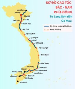
This update concerns the progress of the North-South Expressway project, a core component of the Vietnam Transport Infrastructure 2026 network, aimed at optimizing logistics connectivity from Lang Son to Ca Mau.
3. Connectivity Comparison Matrix for Vietnam Transport Infrastructure 2026
| Infrastructure Factor | Northern Corridor Corridor | Southern Corridor Corridor |
| Deep-water vessel capacity | ~145,000 DWT (Lach Huyen) | ~214,000 DWT (Cai Mep) |
| Port-to-expressway linkage | Direct (Hanoi–Hai Phong Expressway) | Indirect (Urban arterial routing from Cat Lai) |
| Last-mile cost per km | USD 1.80 – 2.20 | USD 2.10 – 2.60 |
| VSIC 30 primary sub-sectors | Shipbuilding, rail equipment | Aerospace, mechanical engineering |
| Air cargo gateway | Noi Bai (Limited cargo capacity) | Long Thanh (Dedicated air cargo hub) |
| ICD maturity | Developing | Established |
| Supplier base depth | Concentrated (Heavy industry) | Diverse (Full ecosystem) |
Source: Datagent Infrastructure & Maritime Connectivity Index (2026), corroborated by DRVN, Decision No. 1579/QĐ-TTg (seaport master plan to 2030), and VIMC operational data.
4. Matching Your Manufacturing Footprint to Vietnam Transport Infrastructure 2026 Assets
The optimal location depends on three factors: your primary export market (which determines port routing), your cargo profile (which determines required road specifications and carrier capabilities), and your supply chain dependencies (which determine whether you need the north’s China-proximate supply chains or the south’s diverse local ecosystem). All of these rely entirely on the surrounding vietnam transport infrastructure 2026 setup.
Site selection for VSIC 30 projects requires granular data on weight limits, bridge clearances, toll structures, industrial zone lease terms, and the firmographic landscape of potential suppliers and logistics partners already operating in each corridor — exactly the kind of integrated intelligence that Datagent’s DGENT Platform delivers alongside company-level data across the vietnam transport infrastructure 2026 manufacturing corridors.
Planning a manufacturing investment? Book a consultation with Datagent’s market research team for a tailored corridor assessment that maps infrastructure connectivity, logistics cost projections, and competitor positioning against your specific manufacturing and export requirements under the vietnam transport infrastructure 2026 master plan.
5. Frequently Asked Questions Regarding Vietnam Transport Infrastructure 2026
5.1. Where should I locate a factory in Vietnam for manufacturing?
The choice between northern and southern corridors depends on your sub-sector and export routing. Shipbuilding and rail equipment benefit from the north’s superior highway connectivity and proximity to Chinese supply chains. Aerospace and precision engineering benefit from the south’s deeper port capacity, diverse supplier base, and the future Long Thanh air cargo hub. The northern vietnam transport infrastructure 2026 routes are 17–21% cheaper for port-to-factory logistics; the south offers deeper operational ecosystem depth.
5.2. What is the capacity of Vietnam’s deep-sea ports?
Vietnam’s deepest port — Cai Mep International Terminal (CMIT) in the south — can handle ultra-large vessels up to 214,121 DWT (reduced load), placing it among the top 20 globally. Lach Huyen in the north handles vessels up to approximately 145,000 DWT. Both are positioned for growth under the national vietnam transport infrastructure 2026 seaport master plan to 2030 (Decision 1579/QĐ-TTg).
5.3. When will Long Thanh International Airport be operational?
Construction is being accelerated under direct Prime Minister directive as of May 2026. The project will create Vietnam’s primary air cargo hub for the southern region, with significant implications for aerospace component logistics. Exact operational dates are subject to construction progress — monitor official project updates to see how this fits into the vietnam transport infrastructure 2026 schedule.
5.4. Why are logistics costs higher in southern Vietnam?
The southern corridor’s cost premium (17–21% higher than the north for a typical container run) is driven by one structural factor: Cat Lai and surrounding ports lack direct expressway linkage to industrial zones. Container traffic routes through urban HCMC, creating congestion that inflates trucking rates, extends turnaround times, and compounds fuel costs. The north’s vietnam transport infrastructure 2026 network bypasses this problem entirely via the Hanoi–Hai Phong Expressway.
5.5. How does infrastructure affect manufacturing site selection costs?
Beyond the obvious logistics cost differential, infrastructure connectivity determines your demurrage exposure (better highway access = faster customs clearance cycle), your carrier options, your compliance timeline, and your ability to implement cost-saving technology like automated route optimization. A site selection decision made without analyzing the vietnam transport infrastructure 2026 network is a ten-year bet placed without checking the odds.
Written by: Jey Nguyen, Senior Analyst at Datagent | [email protected]
About Datagent
Datagent is the trusted intelligence partner for company data and industrial insights across Southeast Asia and India. We integrate firmographics, verified corporate financial performance, and localized micro-economic indicators into a single, structured intelligence layer — helping institutional investors, multinational corporations, and strategy consultants mitigate supply chain risk and accelerate investment decisions across 11 dynamic economies.
Datagent delivers a total of 61 core firmographic fields, comprising 22 operational variables and 39 standardized financial indicators, with full historical coverage across 2022–2024.
This report is for informational purposes only and does not constitute financial advice or an invitation to invest.